Austria, officially the Republic of Austria, is a federal republic and a landlocked country of over 8.7 million people in Central Europe.
Travelling the world through postcards... Stamped postcards I received from postcrossing and direct swapping!
Showing posts with label mapcards. Show all posts
Thursday, March 9, 2017
Argentina
Argentina claims sovereignty over part of Antarctica, the Falkland Islands , and South Georgia and the South Sandwich Islands. The earliest recorded human presence in the area of modern-day Argentina dates back to the Paleolithic period. The country has its roots in Spanish colonization of the region during the 16th century. Argentina rose as the successor state of the Viceroyalty of the Río de la Plata, a Spanish overseas viceroyalty founded in 1776.
Map of Algeria
Algeria, officially the People's Democratic Republic of Algeria, is a sovereign state in North Africa on the Mediterranean coast. Its capital and most populous city is Algiers, located in the country's far north. With an area of 2,381,741 square kilometres (919,595 sq mi), Algeria is the tenth-largest country in the world, and the largest in Africa.
Wednesday, December 16, 2015
Bosnia and Herzegovina mapcard
Bosnia and Herzegovina, sometimes called Bosnia-Herzegovina, abbreviated BiH, and in short often known informally as Bosnia, is a country in Southeastern Europe located on the Balkan Peninsula. Sarajevo is the capital and largest city. Bordered by Croatia to the north, west, and south; Serbia to the east; Montenegro to the southeast; and the Adriatic Sea to the south, with a coastline about 20 kilometres (12 miles) long surrounding the city of Neum. In the central and eastern interior of the country the geography is mountainous, in the northwest it is moderately hilly, and the northeast is predominantly flatland. The inland is a geographically larger region and has a moderate continental climate, bookended by hot summers and cold and snowy winters. The southern tip of the country has a Mediterranean climate and plain topography.
JAMAICA mapcard
Monday, October 26, 2015
Madeira, Portugal
Madeira is a Portuguese archipelago located in the north Atlantic Ocean, west and slightly south of Portugal. Its total population was estimated in 2011 at 267,785. The capital of Madeira is Funchal on the main island's south coast.
This card was posted from England.
Lisbon map and views
Lisbon is one of the oldest cities in the world, and the oldest in Western Europe, predating other modern European capitals such as London, Paris and Rome by centuries. Julius Caesar made it a municipium called Felicitas Julia, adding to the nameOlissipo. Ruled by a series of Germanic tribes from the 5th century, it was captured by the Moors in the 8th century. In 1147, the Crusaders under Afonso Henriques reconquered the city and since then it has been a major political, economic and cultural centre of Portugal. Unlike most capital cities, Lisbon's status as the capital of Portugal has never been granted or confirmed officially – by statute or in written form. Its position as the capital has formed through constitutional convention, making its position as de facto capital a part of the Constitution of Portugal.
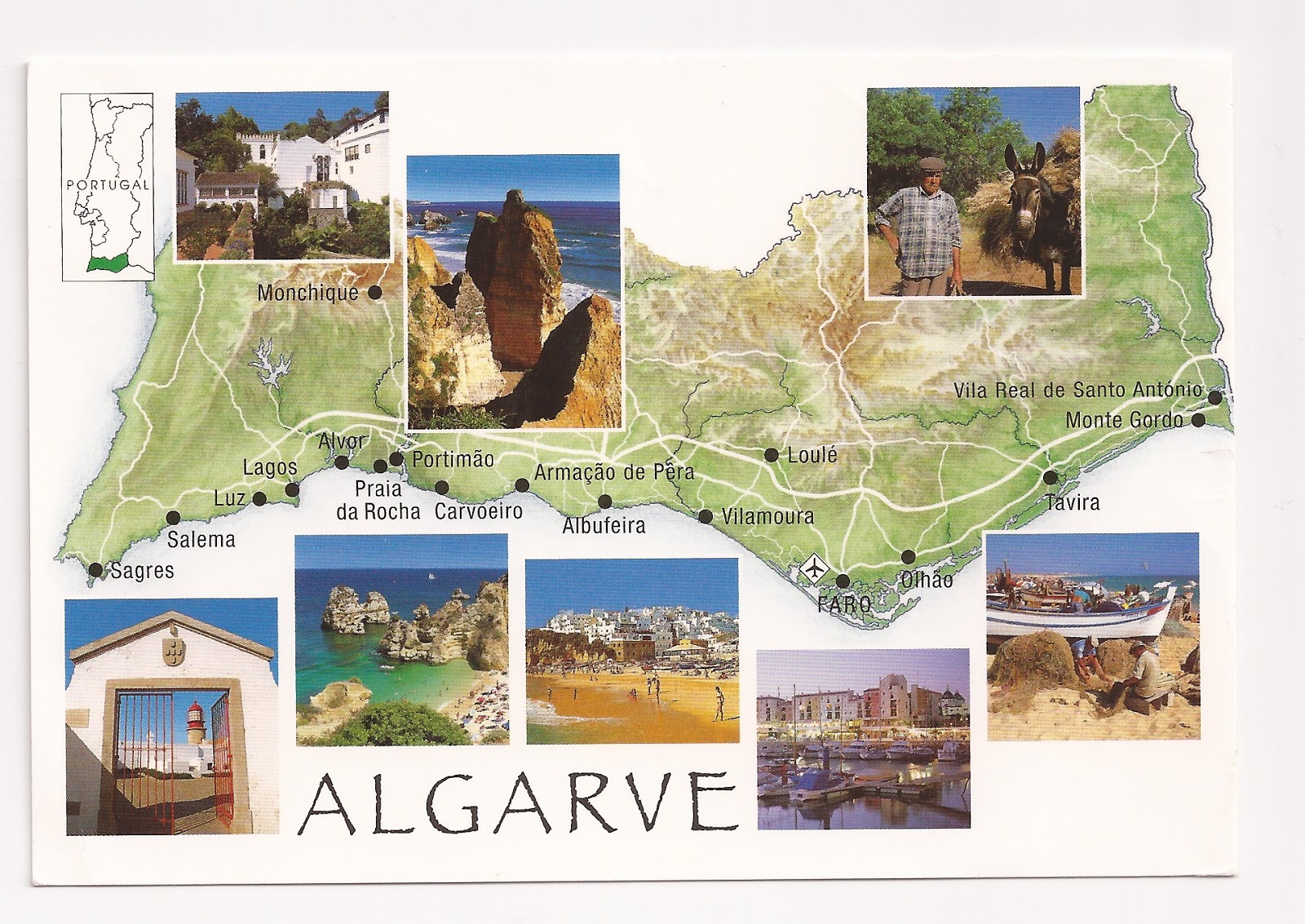
Algarve, Portugal
The Algarve is the southernmost region of mainland Portugal. It has an area of 4,997 square kilometres (1,929 sq mi) with 451,006 permanent inhabitants, and incorporates 16 municipalities. The region has as its administrative centre in the city of Faro, where both the region's internationalairport (FAO) and public university (the University of the Algarve) are located. Tourism and related activities are extensive and make up the bulk of the Algarve's summer economy. Production of food, which includes fish and other seafood, fruit, oranges, carob beans,figs and almonds, is also economically important in the region. The Algarve is the most popular tourist destination in Portugal, and one of the most popular in Europe. Its population triples to nearly 1.5 million people in the peak holiday season thanks to seasonal residents, and receives an average of 7 million foreign tourists each year. In total, including national visitors, almost 10 million people visit the Algarve annually.
Ireland mapcard
Map of Ireland
Ireland is an island in the North Atlantic separated from Great Britain to its east by the North Channel, the Irish Sea, and St George's Channel. It is the second-largest island of the British Isles, trailing only Great Britain, the third-largest in Europe, and the twentieth-largest on Earth.
Politically, Ireland is divided between the Republic of Ireland (officially also named Ireland), which covers five-sixths of the island, and Northern Ireland, a part of the United Kingdom, which covers the remaining area and is located in the northeast of the island. In 2011 the population of Ireland was about 6.4 million, ranking it the second-most populous island in Europe after Great Britain. Just under 4.6 million live in the Republic of Ireland and just over 1.8 million live in Northern Ireland.
Northern Ireland mapcard
Northern Ireland is a constituent unit of the United Kingdom of Great Britain and Northern Ireland in the northeast of the island of Ireland. It is variously described as acountry, province, region, or "part" of the United Kingdom, amongst other terms. Northern Ireland shares a border to the south and west with the Republic of Ireland. In 2011, its population was 1,810,863, constituting about 30% of the island's total population and about 3% of the UK's population. Established by the Northern Ireland Act 1998 as part of the Good Friday Agreement, the Northern Ireland Assembly holds responsibility for a range of devolved policy matters, while other areas are reserved for the British government. Northern Ireland co-operates with the Republic of Ireland in some areas, and the Agreement granted the Republic the ability to "put forward views and proposals" with "determined efforts to resolve disagreements between [the two governments]"
Lough Neagh, Largest lake in Ireland
Lough Neagh, sometimes Loch Neagh, is a freshwater lake in Northern Ireland. The largest lake by area in the British Isles, it supplies forty percent of Northern Ireland's water. Its name comes from Irish: Loch nEachach, meaning "Lake of Eachaidh", although today it is usually spelt Loch nEathach in Irish.The lough is owned by the Earl of Shaftesbury.
Wednesday, August 12, 2015
Trinidad and Tobago mapcard
It is part of South America as it lies on the continental shelf. However usually considered part of the Caribbean, it shares maritime boundaries with other nations including Barbados to the northeast, Grenada to the northwest, Guyana to the southeast, and Venezuela to the south and west. The country covers an area of 5,128 square kilometres (1,980 sq mi) and consists of two main islands, Trinidad and Tobago, with numerous smaller landforms. The two main islands are divided into nine regions, and one ward. Sangre Grande is the largest of the country's nine regions, comprising about 18% of the total area and 10% of the total population of the country. Trinidad and Tobago lies outside of the hurricane belt.
Monday, August 3, 2015
Friesland map, Netherlands
Friesland or Frisia is a province in the northwest of the Netherlands. It is situated west of Groningen, northwest of Drenthe and Overijssel, north of Flevoland, northeast of North Holland, and south of the North Sea.
Drenthe map, Netherlands
![]() |
| NL-1052050 |
Ameland map, Netherlands
![]() |
| NL-1056383 |
Ameland is a municipality and one of the West Frisian Islands off the north coast of the Netherlands. It consists mostly of sand dunes. It is the third major island of the West Frisians. It neighbours islands Terschelling to the West and Schiermonnikoog to the East. This includes the small Engelsmanplaat and Rif islands to the East.
Netherlands mapcard from Postcrossing
![]() |
| NL-685225 |
Subscribe to:
Posts (Atom)